The human cost of Kenya’s expanding lakes
As Kenya’s Rift Valley lakes expand, swallowing homes, farms, and infrastructure, what appears as a climate anomaly reveals a reckoning with ecological limits, failed planning, and the illusion that water would stay where it was put.
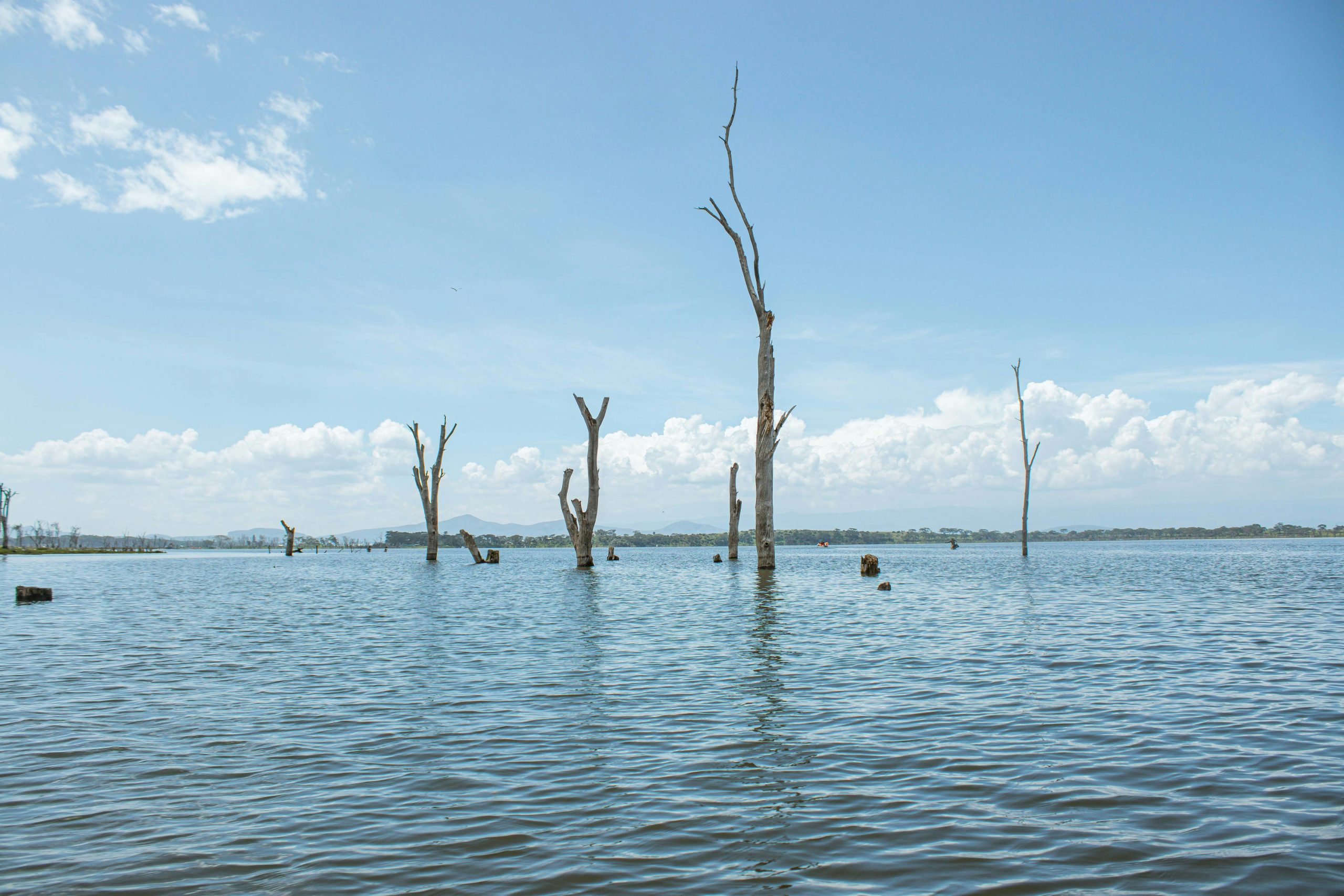
Photo by Brian Kungu on Unsplash
Last year, in one of those overly fun Nairobi evenings that tricks you into thinking the world is orderly, I was walking along Tom Mboya Street, with its streetlights flickering on, and the last of the matatus coughing exhaust into the dusk, and me, just out of a literary event, still carrying the residual buoyancy that follows extended conversation about books.
I was heading toward the last matatu at my stage, phone in hand, scrolling through the after-notes, when the phone rang. It was my mother. That wasn’t unusual. She calls at odd hours, usually to relay some piece of village gossip or to ask if I have eaten. But this time it was different. Her voice didn’t have the usual rhythm. It was tight. Not panicked—my mother doesn’t panic—but compressed, like she was squeezing the words out of a narrow space.
“It’s your aunt,” she said. “Her place. It’s gone.”
I stopped walking. “What do you mean, gone?”
“The water,” she said. “It came up yesterday. She woke up this morning, and the living room . . . there was water where the living room used to be.”
There was a pause, and in that pause I could hear something I couldn’t place at first. Not her breathing. A sound underneath her voice, distant and wet. The slap of something against something. Then she said, “I’m at her place now. Or what was her place. We are standing in the road. The water is still rising.”
I leaned against a building wall. The street was still there—the neon from the club down the block, a man selling smocha on the corner—but suddenly it felt like a postcard held up in front of a flood. I asked the stupid question people always ask: “But how? It hasn’t even rained that much.”
She didn’t answer right away. I think she was watching something. When she spoke again, her voice had shifted, grown quieter, as if she didn’t want whoever was standing next to her to hear. “It’s not rain,” she said. “It’s the lake. It’s been coming for months, but no one . . . we thought it would stop. It doesn’t stop.”
I could see it then, not the lake—I was a hundred kilometers away—but the scene she was standing in: the tarmac gone soft at the edges, the acacia trees standing in water up to their trunks, the dark line on the walls of my aunt’s house like a bath ring. And my mother, maybe still in her church clothes, holding her phone to her ear, watching a relative’s life dissolve by the inch. I wanted to say something useful. Something like, What can I do? But I knew what she’d say. Nothing. No one could do anything.
The lake was always waiting
There is a story we always told ourselves as kids growing up in Naivasha about the lake that was a bad lie we became comfortable with. It is the lie of stasis—that the water knows its place, that boundaries drawn by men are respected by nature, and that the world arranged around us will remain so. For decades, the lake retreated, ceding ground to the ambitions of farmers, and to the appetites of Naivasha’s multibillion-shilling horticulture industry. Residents, in their wisdom, built upon that abandoned bed. We planted flowers where the water once breathed. We laid roads across its memory. And we called it progress.
It appears, the lake was just waiting.
Since 2010, something shifted. Geologists will give you measured language and call it anomalous hydrological activity. What began as a slow seep that you could ignore for a season turned into a relentless surge. By 2020, the waters had risen to heights unseen since 1932—approaching a watermark set when Teddy Roosevelt was still shooting hippos in the Rift and calling it exploration. The shoreline marched up to a kilometer and a half inland in some sectors. At the height of its expansion, the water was swallowing land at a staggering rate of 30 to 90 meters per month. You could go to sleep in June, with your property line a hundred meters from the water and by August, you’re wading through your kitchen.
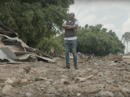
The landscape at the shores of Lake Naivasha is now a cemetery of industry. The Yellow Fever Acacia forests, once the iconic backdrop of the Rift Valley, have been drowned, their white, skeletal trunks standing in stagnant pools. Hundreds of buildings have been submerged; dozens of kilometers of roads have vanished beneath the surface. The multibillion-shilling flower industry, the lifeblood of the region, has seen its greenhouses swallowed whole, displacing thousands of workers whose livelihoods were tied to land the lake has now reclaimed.
There is a paradox that catches in your throat. A growing freshwater lake—you would think that’s a good thing, a sign of ecological health, and a rebuke to drought. But here, it acts as a destroyer. Scientists point to a cocktail of causes, such as erratic, heavy rainfall patterns, the steady sedimentation of the lake floor, and perhaps even deep tectonic shifts within the Rift Valley. But the result is singular: a 21 percent increase in surface area that refuses to retreat.
The locals have stopped calling it a flood, as floods go down and are temporary. What is happening now is a resetting of boundaries. The land humans borrowed for a century was always, in the lake’s memory, part of the water.
Regional reckonings
What is happening at Lake Naivasha is not an isolated event. It is part of a larger, basin-wide transformation affecting the entire Kenyan Rift Valley and beyond. Between 2010 and 2020, lakes across the region expanded at rates that have forced scientists, policymakers, and residents to rethink long-held assumptions about the stability of these water bodies. Lake Baringo’s surface area increased by more than 108 percent. Lake Nakuru grew by 70 percent. Lake Bogoria swelled and even Lake Victoria, though not a rift lake by formation, experienced record-breaking rises in 2020, influenced by the same regional dynamics.
Professor Erustus Kanga, director general of the Kenya Wildlife Service, has previously offered a view that extends beyond Naivasha’s boundaries. “All the Rift Valley lakes have been rising,” he states flatly. “Kenya is not unique; we’re seeing this phenomenon from Ethiopia to Zambia.” The statement was meant to contextualize, but for those who have lost homes and land, it offers cold comfort. The lake is not singling them out but is part of a regional transformation that spans countries and ecosystems.
This expansion is driven by a complex interplay of geological, climatic, and human-induced factors, each compounding the others, and each making the outcome more difficult to predict or control.
The East African Rift is an active divergent boundary where the African plate—specifically the Nubian and Somali plates—is pulling apart. This tectonic activity, ongoing for millions of years, may be playing a more immediate role in the current crisis. Recent movements appear to have altered underground permeability, reducing the subterranean outflow—the natural seepage—that historically helped regulate water levels in these closed-basin lakes. When water cannot drain underground, it has nowhere to go but outward.
Compounding this is underground siltation. Increased sediment loads from surrounding degraded landscapes have, over time, clogged the underground water paths that once served as natural drainage systems. With these pathways blocked, water becomes trapped within the lake basins, accumulating year after year with no outlet.
Climate patterns have also shifted dramatically. The Indian Ocean Dipole (IOD)—a climate system driven by temperature differences across the Indian Ocean—has repeatedly pushed abnormally heavy rainfall onto East Africa. When the western ocean runs warmer than the eastern, moisture piles toward the coast. This phenomenon, often compounded by El Niño, was a primary driver of the severe flooding witnessed across the region in recent years. Between 2019 and 2020, a particularly strong positive IOD event coincided with record rainfall levels across the Rift Valley, accelerating lake expansion beyond anything seen in decades.
Human activity has compounded these forces. The Mau Forest Complex—Kenya’s largest water tower—has lost roughly a quarter of its cover to encroachment and illegal logging. Indigenous forests absorb rainfall slowly, releasing it into groundwater; when they are cleared, water rushes straight into rivers and lakes instead.
The consequences are stark. Rainfall that once soaked slowly into the earth now surges directly into rivers like the Njoro and Mara, driving flash floods and sustained high water levels. Poor farming practices have meanwhile stripped hillsides bare, sending silt into lake basins where it raises the floor—so that the same volume of water spreads wider, year by year, over surrounding land. The human and ecological costs of this expansion are severe and unevenly distributed.
At Lake Baringo, the water rose sharply, displacing more than 5,000 people and submerging homes, schools, and health facilities. Nearby, Lake Bogoria—alkaline, home to the algae that sustains its famous flamingo populations—is nearing a potentially catastrophic convergence with the freshwater Baringo. If the two lakes merge, the chemical disruption could wipe out the conditions that flamingos depend on. At Lake Nakuru, a 50 percent increase in surface area has diluted the lake’s alkalinity, disrupting the conditions that once supported its legendary flamingo flocks. The birds have migrated elsewhere. The iconic image of Nakuru’s pink-fringed shores—a cornerstone of Kenya’s tourism identity—has dimmed. Even Lake Victoria, geologically distinct from the Rift lakes, saw record-breaking rises in 2020, driven by the same regional rainfall. Shoreline communities were displaced; infrastructure was damaged. The interconnectedness of the region’s water systems has become impossible to ignore.
The Rift Valley is not experiencing a series of isolated floods but undergoing a systemic transformation, driven by tectonic processes beneath the earth, climatic shifts above it, and human decisions at the surface. The lakes are responding to forces set in motion across decades and, in some cases, across millennia. The question facing the region is no longer how to stop the expansion, but how to live with it.
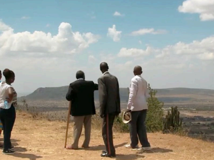
Lives submerged
For the communities living along the edge of Lake Naivasha, the rising waters are not a distant statistic or a scientific debate, but daily reality of lives submerged both literally and figuratively. In settlements like Kihoto, where the lake has swallowed streets and turned some neighborhoods into canals, residents navigate their world in boats where they once used footpaths.
James Otieno has been displaced twice in three years. He stands at what was once the edge of his community, gesturing toward a cluster of rooftops that now break the water’s surface like tombstones. “You can still see where people lived,” he says. “The water doesn’t hide it.” His voice carries no anger—only the exhausted acceptance of someone who has stopped asking why and now only wonders where.
Another resident, Beatrice Wairimu, built her home in 2012, choosing her location with care. She placed it three kilometers from the old shoreline, far enough, she believed, to be safe. The lake had been retreating for years. Everyone said it would continue to retreat. In November 2025, she left for a short trip—a few days, nothing more. When she returned, she found only the roof visible above the water. “A lake that had forgotten where to stop,” she describes it, the phrase carrying both bewilderment and a strange, sorrowful poetry. She does not say the lake forgot. She says the lake forgot “where to stop,” as if the water had once known boundaries and simply chose, one day, to abandon them.
Agnes Njeri cultivated vegetables on a half-acre plot near the lake. She watched the water inch forward over several weeks and not as a dramatic flood or sudden wave, but as a patient, inexorable advance. “Something slow that still managed to surprise us,” she says. The contradiction is the crux of it. She saw it coming. She had time to watch, to measure, to anticipate. And still, when the water reached her doorstep, it felt like an ambush. She lost her land, her crops, a disaster that struck in a day, but one that arrived in increments, giving her just enough time to understand what was happening and not enough time to stop it. The tension between nature’s cycles and human development lies at the heart of the crisis. And by most accounts, development has been losing.
Simon Onywere of Kenyatta University does not mince words when talking about this. He describes decades of poor urban planning and the unchecked subdivision of riparian land as having created what he calls a “theater of the absurd.” Homes were built on land that the lake naturally reclaims every few decades. The patterns were known. The flood zones were mapped. But the pressure for land—for housing, for agriculture, for the flower industry that became the region’s economic engine—overrode caution. People built where they should not have built. And now the water has come to collect what was always, on a geological time scale, its own.
The economic toll has been staggering. The flower industry, a billion-dollar sector for Kenya and the largest employer in the Naivasha region, has seen up to three-quarters of some farms engulfed. Greenhouses that required millions in investment now sit under water. Research facilities—some built by international institutions, some by the government—have been submerged, taking with them years of scientific work and equipment worth millions of shillings. The industry that defined Naivasha’s modern identity is being threatened by the very lake it depended on.
There is one more conflict that cannot be managed with policy or planning. As the lake expands, it pushes wildlife out of its path. Hippos, which once kept to the water’s edge, now roam through areas that were recently residential. They graze on land where children walk to school and wander onto roads at night. The human-wildlife conflict, long a feature of life near Kenya’s protected areas, has taken on a new dimension as the animals are not leaving protected land but the water is bringing them into the spaces where people live.
The shores of Lake Naivasha are lands that held families for generations, now invisible beneath the surface. And among those who know no other home, there is a suspended uncertainty of life in a place where the water may not have finished rising.
A new cartography
It has become difficult, at this point, to maintain the fiction that what is unfolding at Lake Naivasha is either temporary or anomalous. The “high-water mark” is no longer a relic but a new reality. The water has climbed to within a meter and a half of that century-old benchmark, and it shows no sign of retreating to the boundaries that previous generations had come to expect.
For decades, the language used to describe this phenomenon has been the language of the temporary. “Flooding” implied recession. “Crisis” implied resolution. But the lakes of the Rift Valley are not recovering from a weather event but are settling into a new equilibrium. As climate change stabilizes these higher levels through increased rainfall patterns, sustained runoff from degraded catchments, and the steady siltation that raises lake floors, the map of the wider Rift Valley is being permanently redrawn.
This demands a fundamental shift in how we understand our relationship to the water. The water has not transgressed. It has returned to territory it once occupied, territory that was never truly ours to claim in perpetuity. The lake has simply reclaimed its original shoreline.
For people like James Otieno, displaced twice, or Agnes Njeri, who watched the water take her half-acre inch by inch, the failure is as much natural as it is institutional. The crises unfolding along the shores of Naivasha, Baringo, Nakuru, and beyond demand a transition from disaster response to long-term riparian zone management. For years, the pattern has been reactive: waters rise, homes are submerged, families are displaced, emergency aid is deployed. Then the waters stabilize, and the cycle begins again. This is not sustainability but a ritual of loss repeated.
Policy reform is urgently needed. Kenya must embrace and enforce “Room for the Lake” initiatives—approaches that move away from hard engineering solutions like dykes and barriers, which have proven inadequate against the scale of this expansion, and toward natural buffers that acknowledge the lake’s right to fluctuate. When walls are built against water, the water eventually finds a way around them. When space is ceded to the lake—when riparian zones are protected, and when development is kept at a safe distance—both the lake and the people who live near it can coexist.
Central to this effort is clear demarcation. The riparian line—set at 1,892.1 meters above sea level—must be visibly marked and legally enforced. Developers, farmers, and families need to know, with certainty, where the water is likely to go. Without clear boundaries, the pattern of building in the flood path will repeat itself, generation after generation, each cycle more costly than the last. The knowledge exists. The measurements exist. What has been missing is the political will to act on them.
And then there is the question of those already displaced. Providing affected families with land titles in safe zones is, by any measure, more cost effective than the perpetual cycle of emergency aid. Each time the waters rise, the government and humanitarian organizations spend millions on temporary shelters, food aid, and relocation efforts that do not address the underlying reality. A single investment in secure, permanent resettlement—on land that will remain above water—ends the cycle. It returns to families what the lake has taken: stability.
My aunt now lives on higher ground, if you can call it living. She is landless. The plot she bought with years of savings, the three-bedroom house she watched being built brick by brick, the kitchen garden where she grew sukuma wiki—all of it sits under water that we know might never recede. She moved in with relatives first, then to a government-provided tent, then to a single room in a settlement farther from the lake than she has ever lived.
She is sixty years old. She does not say she will rebuild. She says she is tired. The water took not just her house but the idea that she could ever be secure again. She is one of thousands in the Rift Valley who have learned the same bitter lesson: When the lake decides to reclaim its territory, it does not distinguish between ancestral land and new investment, or between a flower farm employing hundreds and a widow’s half-acre. It simply rises. And those who survive it do so not by winning, but by retreating—again and again—until there is nowhere left to go.